


Michigan’s Iron Belle Trail
If you spend enough time slowly biking or hiking, roads or trails, you are sure to look through and look past the many mile markers that point the way. Look too casually, though, and you might miss some useful information.
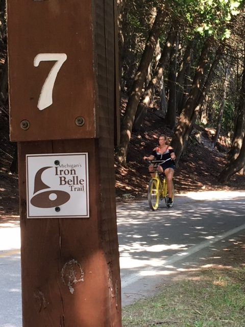
In fact, recently I slowed on a bike ride because I noted an unfamiliar addition to the Mackinac Island mile markers. I asked my wife if she knew what the new designations were, after which we both learned about Michigan’s Iron Belle Trail.
The longest designated state trail anywhere in the country, running from Belle Isle in southern Michigan to Ironwood in the western Upper Peninsula. The trail crosses through 48 counties and extends more than 2,000 miles.
Passing through forests, along lakeshores, and through dozens of small towns, the trail is a partnership between the Michigan Department of Natural Resources and a host of other organizations, including the North Country Trail Association and the Michigan Trails and Greenways Alliance, as well as several others.
Some controversy did accompany the trail’s launch, as Governor Rick Snyder declared in 2012 his intention to make Michigan a leader in trail systems, indicating his plan included the North Country Trail in the Upper Peninsula. Trail enthusiasts and North Country Trail supporters were surprised, as they had not been involved in the initial decision-making process.
Since then, the DNR, working with those partners, has continued to link many of the state’s trails into the Iron Belle system, stretching from the southern edge near Detroit to the far reaches of the western Upper Peninsula.
While the hiking portion of the trail courses along the western side of the Lower Peninsula, the biking portion takes a more east coast route. In the Upper Peninsula, the routes trade places for a time. Some gaps still exist, but the routes do link along existing roadways in a lot of locations, so a traveler might make the entire loop. Through the Straits of Mackinac, of course, the two loops converge to get across the water, which is why we see the markers on Mackinac Island. On the north side of the bridge, the trails diverge again, both west and north of St. Ignace.
The Iron Belle Trails is now part of more than 12,000 miles of trail systems in Michigan, so next time you are hiking or biking through any part of the state’s myriad network of trails, be on the lookout for the now familiar brown arc logo of the Iron Belle Trail.